
Critical Data for Sonoma County
Consortium Funding
What is the Veg Map?
Local Expertise
Timeline
Advisers
1-minute LiDAR Demonstration Video
Critical Data for Sonoma County
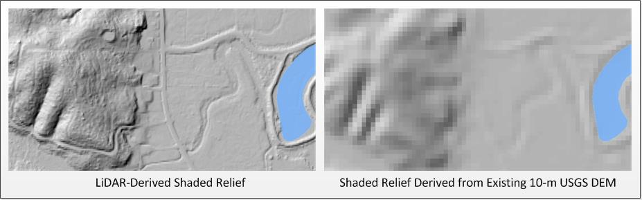
The publicly available datasets produced by this program (see full list here) – including countywide LiDAR data and a fine scale vegetation and habitat map – provide an accurate, up-to-date inventory of the county's landscape features, ecological communities and habitats. These foundational data sets are key to facilitating good planning and management for watershed protection, flood control, fire and fuels management and wildlife habitat conservation. These data are also critical to assessing climate mitigation and adaptation strategies and benefits provided by the landscape, such as the amount of carbon sequestration in forests or the degree to which riparian areas, floodplains, and coastal habitats may buffer extreme weather events.
Consortium Funding
The District, the Water Agency, and their partners have worked together to procure the necessary funding for all program elements including the vegetation and habitat map, LiDAR data, and a suite of additional next-generation data products collected in fall, 2013 including high resolution topography, building outlines, roads, and high resolution aerial photography. State and federal partners are responsible for funding approximately 58% of the program, with the remaining 42% coming from Sonoma County partners. The core funding for the LiDAR data products comes from a NASA grant to the University of Maryland. For more information on the NASA grant, see our press release.
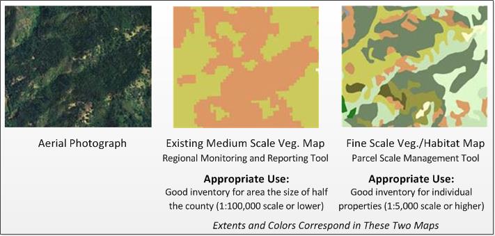
What is the Veg Map?
The District, the Water Agency and their partners developed a classification of the county's vegetation types and physical features, analyzed the LiDAR data and high resolution aerial imagery using human interpreters and computer algorithms, and verified vegetation characteristics in the field. The result is a fine scale vegetation and habitat map for the entire county (click here for more on methods). LiDAR data has increased vegetation map accuracy and provided three dimensional data regarding the built environment, forest structure, and landscape features such as streams and wetlands – all of which support multiple applications for:
- natural resource planning
- land conservation
- sustainable community and climate protection planning
- public works projects
- hydrologic evaluations
- watershed assessments and planning
- disaster preparedness
Local Expertise
Tukman Geospatial LLC, a Sonoma County-based geospatial technology firm with specific expertise in vegetation mapping, serves as the primary contractor for mapping and data collection. Supporting Tukman Geospatial are Kass Green and Associates, Watershed Sciences, Inc., Prunuske Chatham, Inc., the California Native Plant Society (CNPS), Dr. Jarlath O'Neil- Dunne (University of Vermont), and Kruse Imaging. The program has an array of advisers, including the Vegetation Mapping and Remote Sensing Advisory Committee, which advises the mapping team on state-of-the art mapping techniques and methods.
Timeline
The program, which began in 2012, will last five years. Field work to develop a vegetation classification for Sonoma County was conducted in 2013 and 2014. LiDAR and aerial photography were acquired in late 2013 and are now available; vegetation and habitat mapping was completed in 2017. A list of map and data products is shown in the full list of data products.
Technology Advisers
The Vegetation Mapping and Remote Sensing Advisory Committee, comprised of 15 experts in remote sensing, GIS, vegetation mapping, and technology, advises the mapping team on technical issues and the keeps the team up to speed on the newest mapping methods and technologies. For more information on the technical advisory committee - including a list of members - click here.
Ecology Advisers
The Local Ecology and Botany Group, made up of about 35 experts in ecology, botany, and land management, provides expert local botanical and ecological insight to help make the most comprehensive, accurate, and useful map possible. For more information on the ecology advisers - including list of group members - click here.
Last updated: December 3, 2020 at 21:09 pm
Subscribe to Email Newsletters, Program News, and Data Updates
Contributing Partners
Blog Posts
- Kincade Fire
- WHR Crosswalk for Sonoma Veg Map
- 1942 Imagery and Historic Photo Viewer Updated
- Fires
- Fine-Scale Vegetation and Habitat Map Now Available!
- Historic 'Soil-Veg' Maps Available for Northern Sonoma Cty.
- Hydrologic Data Products Now Available
- Countywide Lifeform and Cropland Datasets Available
- Water Agency Uses LiDAR Data to Help Restore Riparian Forests
- LiDAR Data Improves County's Road Centerline Maps
Full List of Data Products
One Page Primer on LiDAR
Mapping Program One Page Brochure
2012 Kickoff Meeting Slides (PDF)
2012 Kickoff Meeting Slideshow (YouTube)
Veg Map News
Winter 2019 Data Announcement
Spring 2017 Newsletter
Winter 2016 Newsletter
Fall 2015 Newsletter
Spring 2015 Newsletter
Fall 2014 Newsletter
Summer 2014 Newsletter
Spring 2014 Newsletter
Winter 2014 Newsletter
Fall 2013 Newsletter
Summer 2013 Newsletter
NASA Grant Press Release
ESRI Special Achievement Award (June, 2016)
Press Democrat Article - Nov. 19, 2013
Windsor Times Article - June 18, 2014
Contact Information
Questions? Email Alex Young